
The Trails  /  New South Wales

Munjip Trail

Observation Point, Batehaven to McKenzies Beach, Malua Bay

Registered First Nations Walking 15 to 18 km 1 day Moderate
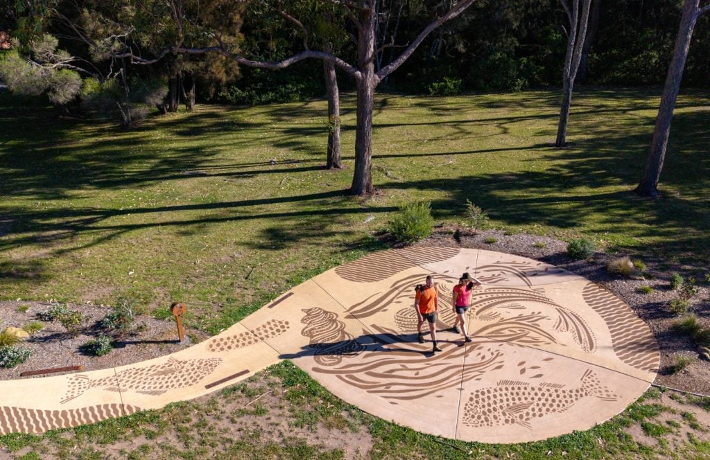
A mural by artist Natalie Bateman on the Munjip Trail

Mural by Natalie Bateman. Photograph by Mark Watson

Places along the way

Headlands, beaches and stories on Walbunja Country.

Around fifteen kilometres of Eurobodalla coast, eighteen if you take every lookout, moving between coastal forest, open headlands, beaches and rock platforms. Artwork, language markers and audio stories from the Walbunja People are woven into the landscape, and QR coded signage connects the physical trail to the living register.

1

Observation Point, Batehaven

The northern trailhead

The walk opens with wide views across Batemans Bay, the Clyde River and out to the Tollgate Islands. From here the trail heads south along the coast on Walbunja Yuin Country, with three trailheads along the way for shorter sections.

Listen to this place
2

The headlands and beaches

Art on Country

Five Walbunja artists and students from Batemans Bay High School created the murals, sculptures and language markers along the trail, including the mural by Natalie Bateman, each honouring connection to Country and the ties between community, story and place.

Listen to this place
3

Pretty Point and Malua Bay headland

Whale country

Lookouts over ancient rock formations make this the trail’s whale watching stretch in the migration seasons, and the walk out to Pretty Point is the reward of the southern half.

Listen to this place
4

McKenzies Beach

Journey’s end

The quieter southern trailhead near Malua Bay, where the trail finishes on the sand. The whole walk can be done in either direction, but heading south keeps the sun at your back.

Listen to this place

History and First Nations stories

“Walking together”, in Dhurga.

More than a decade in the making, the trail was named by Walbunja Elders, who chose a Dhurga word meaning walking together, let’s go, shared by custodian Aunty Loretta Parsley. It was built by Eurobodalla Council in close collaboration with the Walbunja People, and its layered interpretation, public art, language and digital storytelling on Country, won the Interpretation Award at the 2026 National Trust Heritage Awards.

National registration carries that partnership to every Australian as the standard for how a trail’s story should be told, by its custodians, on the ground where it happened.

Stories connected to Country are told only with, and as guided by, their custodians, under the First Nations custodianship protocols at the centre of the register’s governance.

Plan this journey

Itineraries, transport and places to stay.

A sample one day walking itinerary is shown below. The trail can be walked in either direction and has three trailheads, so a few hours on one section is as valid a journey as the whole.

Morning · Sample itinerary

Observation Point to Batehaven

Begin with the views over Batemans Bay and follow the coast south through bushland and beaches, with cafes and water refill points along the way.

Midday

Malua Bay headland

Climb the headland for the lookouts and rock formations, and walk out to Pretty Point for the best views of the day.

Afternoon

McKenzies Beach

Finish on the sand at the southern trailhead, with a swim if the weather allows.

Shorter options

McKenzies Beach to Malua Bay

The southern section is the whale watching walk, a taste of the trail rather than the whole meal, and every trailhead has parking.

Itinerary shown is indicative, prepared for the register’s pilot phase. Final itineraries, transport connections and weather feeds publish with the trail’s national launch.

For schools, walkers and researchers

Take the trail with you.

Support the Trails Donate Become a member