
The Trails  /  Western Australia

Kep Track

Mundaring Weir to Northam

Registered Rail trail Walking Cycling 75 km 1 to 4 days Easy to moderate
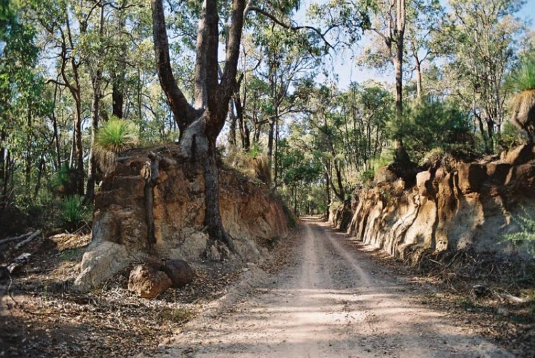
A railway cutting through jarrah forest on the Kep Track

The old railway formation in the Perth Hills. Image courtesy of Trails WA

Places along the way

Weir to river, along the old line.

The track uses the formation of the original Eastern Railway, opened to Northam in the 1880s and bypassed in the 1960s, with C. Y. O’Connor’s pipeline beside it for much of the way. Trailheads at both ends and access at every town along it make the whole journey, or any piece of it, easy to reach. Audio storytelling and QR coded signage will connect the physical trail to the living register.

1

Mundaring Weir

The western trailhead

The journey begins opposite the Mundaring Weir Hotel, beside the weir on the Helena River and the No. 1 Pump Station where O’Connor’s scheme first lifted water toward the goldfields in 1903. Dogs and horses join the track from Firewood Road, three kilometres on, to protect the catchment.

Listen to this place
2

Mount Helena and Chidlow

The hills junctions

Mount Helena was once the busy junction where the main line met the Mundaring branch, and both formations are now trails. Chidlow’s Well has been a refreshment stop for travellers for more than 150 years, and Lake Leschenaultia, a former railway dam, is a short detour for a swim.

Listen to this place
3

Wundowie and Bakers Hill

Foundry and pie shop

Wundowie was built in 1948 as a town for the workers of a charcoal iron and steel plant; the plant has closed but a foundry still operates. Bakers Hill, for all the fame of its pie shop, takes its name from a family rather than a trade, and makes the natural lunch stop.

Listen to this place
4

Clackline to Northam

Journey’s end

Three railway lines met at Clackline in the 1880s, and the track passes the reminders of its junction days before following the pipeline down to Northam. The trail ends at the Poole Street bridge on the Avon River, in a town of century old streets, white swans and Australia’s longest suspension footbridge.

Listen to this place

History and First Nations stories

Water, rail and pipe, on Noongar Country.

Kep is the Noongar word for water, and the track it names runs through the Country of the Whadjuk and Ballardong Noongar people, whose knowledge of water in this landscape long predates the weir and the pipe. Along it came the Eastern Railway, opened to Northam in the 1880s to carry the colony inland, and then C. Y. O’Connor’s Goldfields Water Supply Scheme, which from 1903 pushed fresh water from Mundaring Weir 550 kilometres to Kalgoorlie and still does.

The National Trust of Western Australia conserved the pipeline’s story as the Golden Pipeline heritage project and laid the Kep Track along the old railway formation beside it, so that the water’s first 75 kilometres can be walked, ridden and understood. National registration joins it to its sister entry, the Golden Pipeline drive trail, as two ways of travelling the same idea.

Stories connected to Country are told only with, and as guided by, their custodians, under the First Nations custodianship protocols at the centre of the register’s governance.

Plan this journey

Itineraries, transport and places to stay.

A sample itinerary of three to four days is shown below, using the Transwa train to Northam so the track can be done one way, downhill toward the hills. A fit cyclist can ride the whole track in a long day; on foot it is about fifteen hours of walking, best spread over three or four.

Day 1 · Sample itinerary

Perth to Northam by train

Take the Transwa AvonLink or Prospector from Perth to Northam, with bicycles booked ahead, and stay the night in the town on the Avon.

Days 2 and 3

Northam to Mundaring Weir

Follow the track west through Clackline, Bakers Hill, Wundowie and Wooroloo, with an overnight stop at Wundowie or Chidlow, then on through Mount Helena and Sawyers Valley to the weir.

Day 4

The Mundaring Weir precinct

Visit the No. 1 Pump Station, walk the Weir Walk and the O’Connor Trail, then ride or walk to Mundaring for the bus to Midland and the train home.

Shorter options

A town at a time

Mundaring Sculpture Park to the weir and back is 16 kilometres; from Mount Helena a 14 kilometre loop returns via Sawyers Valley and the Railway Reserves Heritage Trail; or bus to Chidlow and walk the 21 kilometres to Wundowie.

Itinerary shown is indicative, prepared for the register’s pilot phase. There is no public transport between Mundaring Weir and the town of Mundaring; bicycles travel on Transwa trains by booking, not on Transperth buses. Final itineraries, transport connections and weather feeds publish with the trail’s national launch.

For schools, walkers and researchers

Take the trail with you.

Support the Trails Donate Become a member